Wings Over Kansas

State, National & International Aerospace
Trending Resources

  • Home
  • Aviation News
  • History
  • Wings of Education
    • Aviation Education Resources
    • Learn to Fly
  • Pioneers
  • Videos
  • Careers
  • About
  • Contact Us
News Ticker
  • [ March 6, 2019 ] The British Blackburn Buccaneer! Aviation and Aircraft Videos
  • [ March 7, 2025 ] Lockheed Martin – Flying the U-2S Dragon Lady Featured Posts
  • [ March 7, 2025 ] Lockhead Martin – Golden Dome for America Featured Posts
  • [ February 25, 2025 ] What is NATO? Featured Posts
  • [ February 25, 2025 ] The North American Aerospace Defense Command (NORAD) Featured Posts
  • [ January 31, 2025 ] Does Wichita the Aviation Capital have a future? And if so…what is it? Aviation Features
HomeAviation and Aircraft VideosSatellite Imagery: The UAE Expands Its Military Reach!

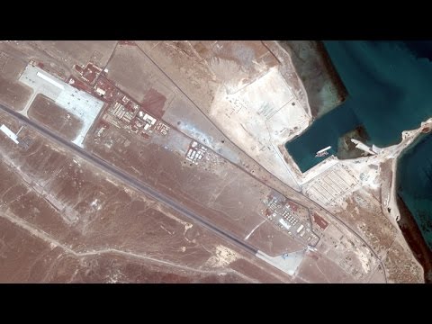
Satellite Imagery: The UAE Expands Its Military Reach!

December 8, 2019 Aviation and Aircraft Videos 0

STRATFOR Military Analyst ‘Sim Tack’ examines satellite images showing Abu Dhabi’s 2016 construction work on a harbor and airport in Eritrea.

Previous

A Brief History of the New US Cold War with Russia w/Max Blumenthal!

Next

How The U.S. And China Are Fighting For Global Power!

Categories

Archives

  • Home
  • Aviation News
  • History
  • Wings of Education
    • Aviation Education Resources
    • Learn to Fly
  • Pioneers
  • Videos
  • Careers
  • About
  • Contact Us

Copyright © 2016. All Rights Reserved. | Wings Over Kansas Legal Disclaimer